Koramangala 4th block flood mitigation plan
favorite 9
murali772 - 13 September, 2018
| Bangalore
| Water
| Citizen Reports
| Bellandur Lake
| flooding, Storm Water Drains
A few weeks back, there was an announcement of the commencement of work on the subject plan, with a pooja, presided over by the BTM layout (under which Assembly constituency, the area falls) MLA, Sri Ramalinga Reddy.
The announcement talked about laying of pipelines along the 80 ft road (Google terms it "Srinivagilu main road"), in the vicinity of Sony-World junction and Maharaja junction, and, with the area already badly congested, there was anxiety among residents to understand what the whole proposal was, as also how it's going to affect their overall mobility.
I requested Mr Srinivas Reddy, EE, BBMP, if he could make a presentation to 4th block (which includes S T Bed layout) residents on the proposal, or at least provide the drawings. But, he seemed to suggest he was busy. Subsequently, I spoke to Mr Govardhan Reddy, the Block Congress convener, and it is based on my understanding of what he had stated that I have put together this report.
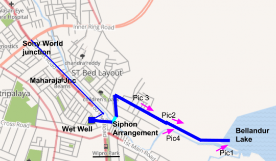
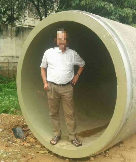
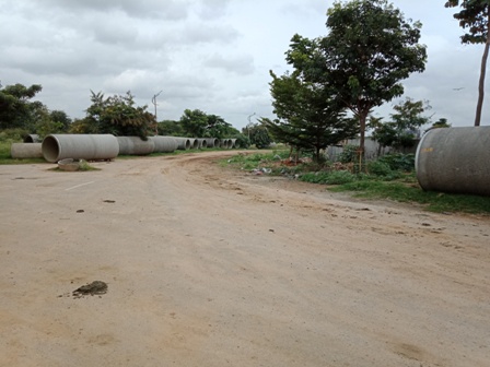
The thin blue line indicates the under-ground pipeline originating somewhere near the Sony-World junction and ending at the "wet-well" somewhere near Wipro (Kamal bakery) junction, into which flood-water accumulating along the stretch will enter through gratings on the surface. From the wet-well, the water is supposed to be taken to Bellandur lake through 6ft dia pipes (seen in picture below, and indicated in deep blue colour, in the picture above).
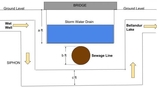
The crossing of the Storm-water drain (SWD), near "Seva-in-Action", is suppsed to be through a 'siphon' arrangement as depicted in the picture below:
Now, there is already a sewage line below the SWD, which if you assume as 4ft dia (b), 'c' is 6ft, and if the bed of the SWD is 12ft from the ground level, then the excavation has to be to a level of minimum 22 ft from the ground level.
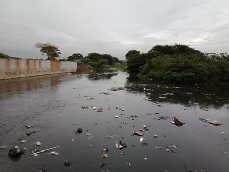
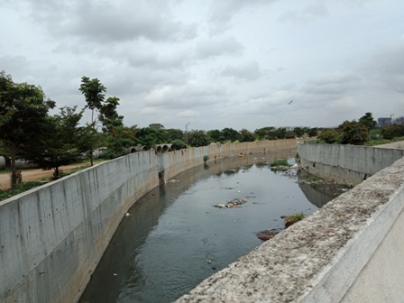
From there, it flows through along points marked PIC3, PIC2, and then along the SWD from PIC4, and empties into Bellandur lake at PIC1 (beyond the SWD wall seen in the picture). The crimson arrows indicate the direction in which the picture were taken.
The whole idea of publishing this report is to help the community understand what is in store, make their own assessments (many are engineers, some specialised in Hydrology, too), and engage with the powers that be to make correctives, if required.
Well, for even for an Electrical Engineer like me, following questions arise:
1) Water (rather sewage) is flowing into the Bellandur lake in the SWD. So, the natural gradient is available. But, is it good enough for high flood discharge? If not, is there a fear of water backing up, and causing bigger damage?
2) The siphon arrangement appears very dicey. There is every chance of muck collecting at the bends and blocking the flow. How is it proposed to be cleaned? And, is it going to be gravity flow through it from the wet-well, or is it going to be pumped?
3) The flood-water channelisation through road-side gratings into under-ground pipeline along the length of the 80 ft road also appears a tricky job.
The bigger question that arises is, when undertaking such massive jobs which have huge impact on the life of the community, shouldn't there have been wider citizen consultations before starting work on it? The entire area is cluttered with those massive pipes, which means huge sums have already been spent.
Well, all in all, the city governance certainly calls for total re-structuring.
Muralidhar Rao
COMMENTS
Met Mr Naveen, JE, BWSSB, along with Maj Kapur, in connection with the problem of sewage from S T Bed area being let into the secondary drain flowing behind Maj Kapur's house. His explanation was that it was a temporary arrangement, since the STP down the main line was majfunctioning. Speaking to Maj Kapur today, it appears the bigger part of the problem has been sorted out, but a small part still remains, which is expected to be sorted out soon.
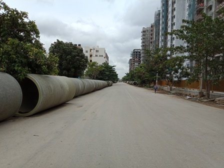
More importantly, what Mr Naveen had to say was that the huge 6ft dia pipes, seen in Nirguna Mandir (Shantinagar Housinbg Society) layout, were not meant for diverting storm water from the 80 ft road, past Sony World/ Maharaja junctions, as told to me by Mr Govardhan Reddy, but for diverting sewage from Passport office/ Games Village area to Bellandur (hopefully via an STP), via 1st main, S T Bed layout. If this is true, life is going to become even more difficult in S T Bed layout.
All in all, totally opaque goings on.
Following are transcripts of exchanges on the subject, on 'whatsapp', clearly bringing out the confusion prevailing:
PS: Work order issued from honourable MLA Sri RamalingaReddy to agency for construction of parallel drain to SWD K-100 from Sony World junction to Bellandur lake to carry excess flood water from Koramangala and adjacent areas
VB: Where would this drain be? Under 80ft rd or 1st Main or ??
PS: Exact details do not know. Parallel drain from Sony junction to avoid flood in koramangala 4th block and 80' road.
Me: Isn't it important that we all know the details, particularly so when many of the past ventures have proved ineffective?
GK: 4th Blockers can enlighten us cos this is driven by them .... the basic scheme we have heard about ... implementation is another challenge for sure.
GK: Running an underground pipe 6-8ft dia along 80ft road ... connecting the 4th block drains to those pipes .... reaching first block park where they plan a transfer pit / well .... then pipes along 7th A main ( Cooks Palace Road) to reach levels below the primary SWD with a tunnel some 10ft below the SWD bed ... then run along Prestige Pinewood towards Bellandur. And also connect ST bed to this line near Bethany school ....This is what I heard was the plan .... however... the key to this success remains basic engineering and gravitational flow principles to ensure that from 10ft below the SWD we can still expect water to flow to Bellandur ( at any point of time we have 3ft water in the primary swd .... ) complications with existing UGD and several service lines below 80ft road , along 7th A main, risk of back flow at Kamal Bakery junction and Park; New UGD lines along same alignment as the box drains planned beyond Bethany .... and ofcourse all this with traffic flow of 80ft road being what it is with no alternative till 100ft road is completed in 2020!
We are always assured that levels are verified and the scanning done along planned routes ... but no transparency in that data being shared with us directly affected parties....
Me: This was another issue I wanted to raise at what perhaps was intended to pass off as a "ward committee" meet last week - but, never got an opportunity
AR: Bangalore, and particularly Koramangala, is becoming absolutely and completely impossible to live in. There are no roads, no lights, only ditches and potholes. And loads of garbage and sewage. And with real estate supply spiking up soon... I wonder what pressure this will have on the value of our real estate here. From Indus River Valley Civilization, we have become Koramangala Drain Valley Uncivilization. Instead of civilizations arising along nurturing rivers, modern day urbanization center's us around drainages. Rather than taking what we need, our rivers now carry what we reject.
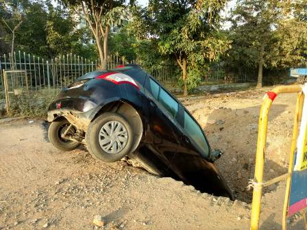
A prominent resident of S T Bed layout, got to check with the highest levels at BWSSB, who have now confirmed to him that the 6 ft dia pipes are for pumping sewage from Passport office/ new Mantri Mall/ Games Village area to Bellandur lake (after treatment at an STP adjacent to the lake). And, the route to be followed is - below the SWD (adjacent to the Games Village area) bed till it crosses the IRR (near Naveen Terraces), and from thereon, below the 1st A Main S T Bed laout, and then below 1st Main till "Seva-in-Action" junction, from where it will go below the Nirguna Mandir layout roads (where the pipe laying is already in progress, and a car has already fallen into the trenches, due to carelessness of BWSSB - check picture) to STP, and finally Bellandur lake.
Many questions arise hereof:
1) If the volume of sewage is so huge that it requires a 6 ft dia pipe to be conveyed, why isn't the BWSSB setting up an STP in the immediate vicinity (between the beneficiaries, they should be able to find the space), instead of spending huge amounts on this highly challenging job, that is besides going to be upsetting the lives of S T Bed layout residents for months/ years together? This is even as the current rules require apartment complexes with more than just 50 units to have captive STP's.
2) The S T Bed 1st A main road is quite narrow and has at least four 90 degree bends. How is such a road going to accommodate the 6 ft dia pipes below it?
All in all, a very poorly thought-through 'adventure', and a very costly one at that, all paid out of tax payers' money. It's going to be even costlier for the S T Bed layout residents if it eventually doesn't quite function properly.
The need for genuine citizen consultation prior to launching on such projects cries out loudly once again.
PRAJA.IN COMMENT GUIDELINES
Posting Guidelines apply for comments as well. No foul language, hate mongering or personal attacks. If criticizing third person or an authority, you must be fact based, as constructive as possible, and use gentle words. Avoid going off-topic no matter how nice your comment is. Moderators reserve the right to either edit or simply delete comments that don't meet these guidelines. If you are nice enough to realize you violated the guidelines, please save Moderators some time by editing and fixing yourself. Thanks!
