HOT TOPICS
SPOTLIGHT AGENCIES
PH2 UG Red line routing
srinidhi - 16 July, 2017 | Bangalore | Analysis | BMRCL | metro | Metro Rail | red line
FInally BMRCL has published the UG route with station details of the new red line coming up between Gotigere and Nagavara. THe line goes UG at Dairy circle and has 12 stations on that stretch. The details are at the link below which was published recently
https://www.google.com/maps/d/viewer?mid=1LL2AAKCW3Zoe_UFxeVSIC5vZxFA&ll=12.991772600000003%2C77.60624710000002&z=17

Some positives from the map is :
- Sholay circle now has a gate closer which will cater to the offices and establishments there
- MG road interchange..not really an interchange in official terms as there is a physical separation of the lines...but now the station on red line seems closer to MG rd stn
- Integration with Shivajinagar bus stand seems good..
But there seems to some huge gaps in the route too..
- Starting with the cantt IR station integration..which seems to be totally missing..the proposed metro station is atleast 1 Km walking distance from the IR ticket counters (>2KM vehicle access).
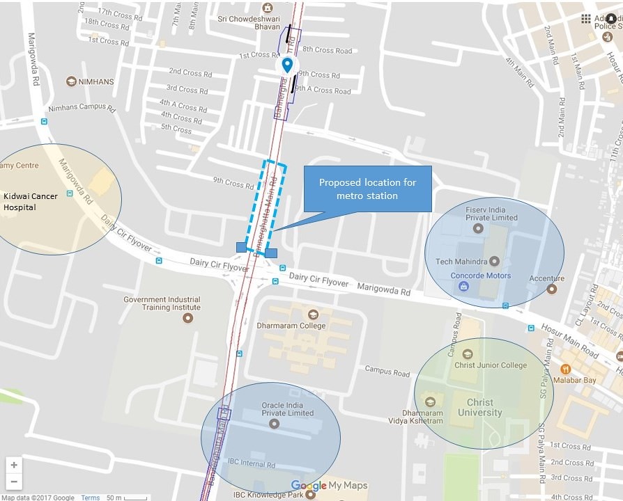
- No integration with the medical facilities or with clusters of IT companies and Christ college at Dairy circle
Please share your thoughts and suggestions..
COMMENTS
Ph3 interchanges?
srinidhi - 18 July, 2017 - 07:21
Interchanges and integrations have been made a joke of with the first two phases of metro in Bangalore.
Glaring mistakes with interchanges were:
RV road interchange of the Green line with Bommanahalli line
MG road interchange (could have gone UG on MG rd and had a seemless interchange with the Nagavara line)
Also BYP extn to whitefield has a wasteful routing today, where the line comes at grade at BYP and then its planned to go OH towards whitefield. Instead design like Peenya depot could have been done at BYP too..would have saved money and time!

So how can interchanges be relooked now with the PH2 lines being tendered out.
1. Interchange at Dairy circle:
The planned UG station at Dairy circle is a few hundred meters away from the Dairy circle. SO eventually if there is a line coming from Agara/HSR, how will it integrate with the line at all?
2. Interchange at Shoolay circle:
The ph3 line coming from city corporation will have a station on residency road..how will it integrate with the Nagavara line?
3. Interchange on ORR near Nagavara
The line on ORR crosses the UG Nagavara line, how is this interchange addressed?
Sir MV planned KRS with a projected capacity so that it could cater seemlessly for many decades. However BMRCL with way much more funds has set some bad precedence already with very poor planning already.
Hope ammends can be made quick!
Short walks to change lines is no big deal
Naveen - 19 July, 2017 - 09:27
MG road interchange..not really an interchange in official terms as there is a physical separation of the lines...No integration with the medical facilities or with clusters of IT companies and Christ college at Dairy circle
Starting with the cantt IR station integration..which seems to be totally missing..the proposed metro station is atleast 1 Km walking distance from the IR ticket counters (>2KM vehicle access).
INTEGRATION? EASY INTERCHANGES CERTAINLY POSSIBLE
Naveen - 19 July, 2017 - 09:46
RV road interchange of the Green line with Bommanahalli lineMG road interchange (could have gone UG on MG rd and had a seemless interchange with the Nagavara line)Also BYP extn to whitefield has a wasteful routing today, where the line comes at grade at BYP and then its planned to go OH towards whitefield. Instead design like Peenya depot could have been done at BYP too..would have saved money and time!
1. Interchange at Dairy circle:The planned UG station at Dairy circle is a few hundred meters away from the Dairy circle. SO eventually if there is a line coming from Agara/HSR, how will it integrate with the line at all?2. Interchange at Shoolay circle:The ph3 line coming from city corporation will have a station on residency road..how will it integrate with the Nagavara line?3. Interchange on ORR near NagavaraThe line on ORR crosses the UG Nagavara line, how is this interchange addressed?Sir MV planned KRS with a projected capacity so that it could cater seemlessly for many decades. However BMRCL with way much more funds has set some bad precedence already with very poor planning already.Hope ammends can be made quick!
opportunity..
srinidhi - 25 July, 2017 - 07:19
@Naveen As you mention the root of the problem with integrations has been:
line extension /interchange were never planned when stations were built as feasibility for future lines were still works in progress then
The situation has lot changed now and hope BMRCL has learnt about the inadequacies of the earlier design.
Though a phase 1 station closer to the MG rd-Brigade rd jn could have helped, Nothing much can be done with the integration at MG road now.
However there is an opportunity at other places. The focus on Cantonment station location now is a good example of that.
Coming to Dairy circle station, BMRCL has noted that the station cannot be located at the circle itself because of the exisiting underpass. WHich is fair and clear. But having station exits right adjacent to the junction is still a possibility and can help in many ways:
- Shorter access to medical facilities Kidwai/Nimhans
- Shorter access to IT office clusters on both Hosur rd and Bannerghatta rd
- Quicker access to educational institutions
- Easier integration with the planned ph3 line crossing there

hope BMRCL can take this change up and plan for the future..
Oh please....again
Naveen - 25 July, 2017 - 12:46
Though a phase 1 station closer to the MG rd-Brigade rd jn could have helped, Nothing much can be done with the integration at MG road now.
Sri... MG rd stn is close enough. 125m from junction is nothing. Please google search & check interchanges elsewhere, including the ones posted by Ravi on whatsapp. All will have 200-300mtrs walk component for interchanges, nothing unusual. Even 400mtrs is very common. Please check & measure walk distances.
You probably never used metro anywhere & haven't noted walk components abroad, even if you have used it some place.
But having station exits right adjacent to the junction is still a possibility and can help in many ways
In your drawing, the new location for the station is overlapping the underpass. Please again re-check properly on google earth. And as I said, metro is built with least disturbance to existing facilities all over the world. An additional 100 mtrs walk is nothing unusual. Where they located is correct as some dstance is required not to tamper with the underpass during station construction. The few shaded institutes are not the only ones to be served. What about the housing colonies on the west, east & north of station?
Further, bear in mind that every phase or every new line cannot be foreseen nor planned decades in advance, except on a short-term basis. Even master plans are always subject to change based on ground situations as they develop.
Example: Who would have thought that a section of the ph-3 line on ORR would have to be fast tracked & included in ph-2 due to hectic pace of development? Even as late as 2011, there was hardly any traffic & few offices on ORR. I know & I can say this because I stay close by.
PRAJA.IN COMMENT GUIDELINES
Posting Guidelines apply for comments as well. No foul language, hate mongering or personal attacks. If criticizing third person or an authority, you must be fact based, as constructive as possible, and use gentle words. Avoid going off-topic no matter how nice your comment is. Moderators reserve the right to either edit or simply delete comments that don't meet these guidelines. If you are nice enough to realize you violated the guidelines, please save Moderators some time by editing and fixing yourself. Thanks!


